A map of customers on a real-world map, created from data, reveals things as they are and takes some of the guess work out of reaching customers. Industries from healthcare to retail to finance to utilities are using location information about their customers and assets to drive superior customer experience, improve process efficiency and lower risk level. Advancements and innovations in geo-spatial technology are driving a new wave of interest in location solutions. Not only does geo-spatial analysis allow companies to use location data to derive unprecedented levels of understanding of customer’s habits and behavior, they also provide the platforms to deliver beneficial information, direction and other support directly to customers.
The ability to visualize your customer base using geography opens up a level of knowledge and understanding not available through any other method. Some of the most important insights that marketing, development and delivery professionals are trying to capture from the value of location data are:
- Where are your customers located in relation to your stores, warehouses and other points of contact? Or, alternatively, where should your distribution centres be located to ensure proximity to your ideal customers?
- Which areas have a greater level of penetration?
- Are your lapsed customers coming from certain areas?
- Which areas have a similar profile to your current base (or your best customers)?
- What’s the fastest, cheapest or safest route to take to deliver your goods to end-users?
- How are your assets – such as poles, meters, towers and stores – distributed across a geographical area? Is this distribution optimal given your intended target market?
- Is store performance linked to geographical location?
Managers in a wide variety of fields are coming to understand the competitive advantages that come with the savvy use of location data, and a few examples are noted below.
Identify Opportunities with Radius Maps
Radius maps, also known as buffer maps, are useful when you need to understand your data in relation to its proximity to other features. They are often used as coverage maps to see where you may have gaps or overlap of coverage of your shops, services, and operations. For instance, you may need to be able to visualize how many customers you have within a 10-mile radius of your office locations, or how many customers you could serve in a particular region if you build a new outlet.
Save Time and Costs with Route Maps
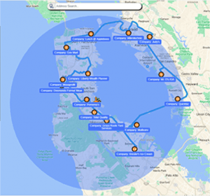 Geo-spatial software can take your chosen stops and optimize a route to reach them all. With options for a round trip, different start and end points and all the intermediate points, you can plan your route in minutes. By optimizing your route, you make sure your sales team’s time is spent in the most efficient manner, saving time and money.
Manage Your Sales Territories
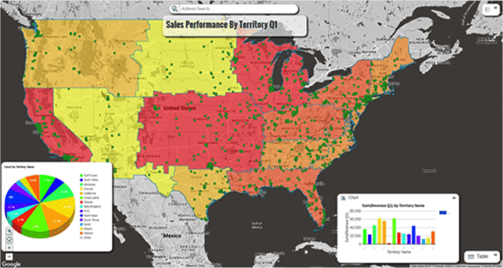 Enhance your maps by combining it with additional visualization tools, such as charts. Charts can give viewers an immediate summary of the data on the map. Geo-spatial software can produce various types of charts which can be added to a map, including bar, line, pie, area, and scatter charts.
Competitive advantage analysis
By overlaying certain location information, such as population density, the road network and store location, organizations can analyze and understand their competitive advantages and disadvantages in the market. Geo-spatial software, together with the appropriate data, can help managers visualize the relationship between the location of your competitors, customers (current and potential) and sales.
For more information on how customer maps can provide valuable marketing and strategy insights, contact us at moc.scimonocesellitna@ofni
Sources: Antilles Economics and www.espatial.com


